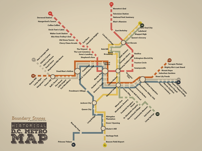
WETA Historical D.C. Metro Map Digital Feature

Washington, D.C.’s Metrorail system touches many different neighborhoods across the District of Columbia, Maryland and Virginia, each of which has its own backstory and character. The map itself, with its colorful lines, is iconic among locals.
WETA Digital created the Historical D.C. Metro Map interactive by identifying quirky and interesting stories for the areas in proximity to each transit stop. The stories were then used to create a reimagined interactive map with new “historical” names for each Metrorail station.
Users explore the feature by selecting a station of interest, viewing photos and a text summary describing the story behind the name. In addition to continuing their historical journey from station to station, users are encouraged to delve into more in-depth articles about the neighborhoods, previously published on the WETA Boundary Stones local history blog. The experience enables a stronger local connection to the community and a stronger sense of place.
Washington, D.C.’s Metrorail system touches many different neighborhoods across the District of Columbia, Maryland and Virginia, each of which has its own backstory and character. The map, with its colorful lines, is well known among locals who, even if they don’t ride Metro personally, have associations with the system.
In our Historical D.C. Metro Map interactive, we took the well-known map, researched each neighborhood and identified quirky and interesting stories from each. Then we used those stories to inform new “historical” names for each Metrorail station and created an alternative map based on the style of the original.
As users click around, they are presented with quippy summaries that describe the historical roots of the new names, along with photos. They are also fed links to more in-depth articles about the neighborhoods, which we’ve published on our Boundary Stones local history blog. The interactive uses responsive design so that it is optimized for desktop and mobile use.


